Date: 30 Sep 2021
All the local authority adaptation strategies identified the need to gather and organise data on the impacts of climate change locally.
The WIRE App was developed to address this need and to provide a simple tool for use by all levels of staff within the local authority sector to record and collate the impacts of weather events in their areas.
The initiative was one of eight projects that received grant assistance under the first Public Sector Innovation Fund launched in 2019 - €25,000 was made available to the CARO towards the development of the App and system.
The concept design, user interface and graphics were developed by the CARO inhouse, with support from Climate Ireland and input from local authorities through a series of workshops. ESRI were engaged to develop the App on the ArcGIS Online and Survey123 platforms.
The App and supporting tools are simple to use and will produce a dataset of valuable information for those involved in developing emergency response, adaptation planning and supporting planners make informed decisions on future development.
WIRE App Elements
There are different elements to the WIRE App that are all available through a Hub Page, along with links to guidance document and instructional videos.
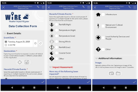
Data Collection Form
A simple data collection form has been developed that can be uploaded to a mobile phone or accessed through the web-based portal. The form is simple and intuitive to use and can be accessed by all local authority staff, whether they have an ESRI licence or not.

The benefits of the system can only be achieved if the information is gathered on the ground during weather events and feeds into a dataset that will build over time. It is envisaged that local authority staff, particularly outdoor staff and first responders to emergency events would have this Data Collection Form available on their mobile phones.
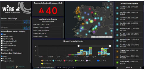
WIRE Dashboard
The dataset from the Data Collection Forms can be viewed on the WIRE dashboard developed alongside the App. This will provide a spatial distribution of impacts and help identify emerging risks, priority areas and inform climate adaptation planning.

Benefits to Local Authorities
If adopted and used by local authorities, the dataset will develop over time and provide valuable information that will help identify areas at particular risk from climate events. These identified areas can then be prioritised for more detailed risk and vulnerability assessment and adaptation planning.
The detailed records of the severity of these events and the frequency of when they impacted a particular area will support evidence-based decision making and investment. In addition, this information may also support the provision of evidence for funding applications, as was required under the Road Adaptation Grant earlier this year.
The dataset from the WIRE system will also be incorporated into a new Climate Change Risk & Vulnerability Methodology being developed by Climate Ireland/CARO and also into the National Flood Forecasting System to help calibrate warnings projections.
Rollout of the WIRE App
The WIRE App was piloted in a number of local authorities in 2020/2021. A number of upgrades and modifications have been made to the system following the feedback from these pilots and to facilitate the rollout across the 31 local authorities.
This upgrading work has now been completed and it is proposed to commence rolling out the system across the sector commencing in October the Atlantic Seaboard North Region before being rolled out nationally through the 4 CAROs.